THE OTHERS’ TRIESTE
Dominika Kopiarova

Trieste – a city at the Adriatic coast – a cosmopolitan port governed for over half a millennia by the Austro-Hungarian Empire. First annexed by Italy and split into two zones, gaining the short-lived status of the Free Territory, and shortly after returned to Italy again.
This represents a single narration on the border city that in its clarity paradoxically obscures Trieste as it was often used as a symbol for competing ideologies on the notions of territory and identity – whether Italian, Austrian or as the Iron Curtain frontier of Western Europe. Trieste’s border condition stems from its territory at the junction of the everchanging state borders, being rather defined by what it is not. A City of Nowhere – as described by Jan Morris.[1]
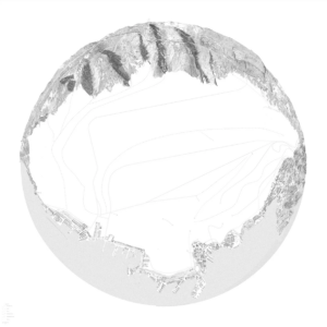
The Territory Map portrays Trieste as that ‘City of Nowhere’. A void ready to absorb the narratives of the others, trapped between the two landscapes truly characteristic of the city – the natural Karst border and the ever-expanding industrial port.
In the map, the hand drawing technique allows freedom in representation and scale, as well as complete control over the narrative as it results from subjective observation. Karst is drawn in an elevation that acts as a barrier, a seafront facade with identifiable architectural and infrastructural elements. On the contrary, the inaccessible port is outlined in a plan. The landscapes meet at two vanishing points – the Miramare Castle on the left and the Istrian Peninsula on the right.

Contrary to the Territory map, if we identify the obscure nature of Trieste as a productive force in unfolding the city rather than a hindrance to precision in spatial representation, obscurity aids in uncovering the complex, the conflicted, and the multiple in mapping. A Border Map stemming from this obscurity then provides a non-linear perspective on the legibility of the Triestine border.
Trieste is a city of complex geopolitical history that defines its contested past and present. Italy, Slovenia (former Yugoslavia), Austria (former Habsburg Empire) and various treaty participants are described as the otherness in Trieste, and hence the others. As these political entities have contrasting interests, Trieste had become a playground for contrary border proposals favouring the respective party.
Historical sources and mappings served as a basis for understanding the city’s contested history and provided a multitude of lenses through which the forces that shaped the Triestine borders were explored. Infrastructural flows – military, freight, migration, railway – were identified as the metric for examining the underlying forces shaping the borders. The map draws on the changes in those flows – fluxes indicative of increased economic trade, infrastructural development or migration. And vice versa – the impacts of rewriting borderlines and cross-border negotiations on the flows. The intensity of the flow reveals the degree of its porosity.
Eight time zones with the highest density of critical events and conflicts straddling the border are isolated, and each historical moment is presented as snapshots to simplify the complexity of the external forces. Zones of different scales containing those key events are identified in Trieste, and infrastructural fluxes that define the physical borders are assembled – a total of 20 fragments of Trieste and areas relevant to understanding its global infrastructure.
The fluxes overcoming geographical and natural borders become the organising principle for reassembling the fragments according to spatial, geopolitical or infrastructural connections rather than in chronological sequence. Therefore, through fragmentation and reassembling, the map embraces the non-linear reading of Trieste.
